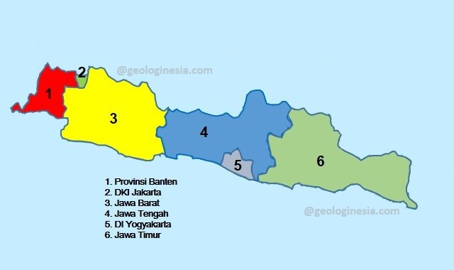
Java is one of the six major islands in Indonesia, java island bordering the Indian Ocean to the south and the Java Sea to the north.
The population on the indonesian island of Java is more than 141 million (only Java) or 145 million (including the population of the surrounding islands), Java constitutes 56.7 percent of the population of Indonesia and is the most populous island in the world.
The capital of Indonesia, Jakarta is located on its northwest coast. Many famous parts of Indonesian history take place in Java. It was the center of a powerful Hindu-Buddhist kingdom, an Islamic sultanate, and the core of the Colonial Dutch East Indies.

A glimpse of the history of Java Island of Indonesia
Java was also the center of Indonesia’s independence struggle during the 1930s and 1940s. Java dominates Indonesia politically, economically and culturally. Four of the eight UNESCO world heritage sites are located in Java: Ujung Kulon National Park, BorobudurTemple, Prambanan Temple, and Sangiran Ancient Human Site.
Formed largely as a result of volcanic eruptions from geological subduction between the Sunda Plate and the Australian Plate, Java is the 13th largest island in the world and the fifth largest in Indonesia by land area of about 138,800 square kilometers (53,600 square miles).
Volcanic mountain chains form the east-west backbone along the island. Three main languages are spoken on the island: Javanese, Sundanese, and Madurese, where Javanese is most spoken; it is the native language of about 60 million Javanese in Indonesia, most of which live in Java. Most of the population is bilingual, speaking Indonesian as their first or second language. Although the majority of Java’s population is Muslim, the population of Java consists of people who have diverse religious, ethnic, and cultural beliefs.
The island of Java Indonesia is divided into six administrative provinces namely Banten, West Java, Central Java, East Java, as well as two special regions (special) Jakarta and Yogyakarta.

Geography of Java Island Indonesian
Java is located between Sumatra in the west and Bali in the east. Kalimantan is located in the north, and Christmas Island in the south. It is the 13th largest island in the world. Indonesia’s Java Island is surrounded by the Java Sea to the north, the Sunda Strait to the west, the Indian Ocean to the south and the Bali Strait and the Madura Strait to the east.
The island of Java Indonesia is almost entirely volcanic; it contains thirty-eight mountains that form the east-west backbone that was once an active volcano. The highest volcano in Java is Mount Semeru, 3,676 meters (12,060 feet). The most active volcano in Java and also in Indonesia is Mount Merapi, 2,930 meters (9,610 feet). In total, Java has more than 150 mountains.
The mountains and highlands of Java divide the inside into a series of relatively isolated areas suitable for wet rice cultivation; rice fields in Java are among the richest in the world. [16] Java was the first place where Indonesian coffee was grown, starting in 1699. Today, Arabica coffee is grown in the Ijen Plateau by small farmers and large plantations.
The area of Java Indonesia is about 150,000 square kilometers (58,000 square miles). [16] It is about 1,000 km (620 mi) long and up to 210 km (130 miles) wide. The longest river on the island is the 600 km Solo River. [17] The river rises from its source in Central Java at Mount Lawu, then flows north and east to the estuary in the Java Sea near the city of Surabaya. Other major rivers are Brantas, Citarum, Cimanuk and Serayu.
Average temperatures range from 22°C (72°F) to 29°C (84°F); average humidity is 75%. The northern coastal plains are usually hotter, with an average of 34°C (93°F) during the day in the dry season. The south coast is generally cooler than the north, and the highlands inland are even cooler. [18] The rainy season begins in November and ends in April. During that time it rains mostly in the afternoon and occasionally during other parts of the year. The wettest months are January and February.
West Java is wetter than East Java, and mountainous areas receive much higher rainfall. Parahyangan city of West Java is a plateau receiving more than 4,000 millimeters (160 in) per year, while the north coast of East Java receives 900 millimeters (35 in) per year.
Berikan komentar bro/sist